
Here is a map and summary of the severe weather events of the day, and specific incidents reported to the National Weather Service in Minneapolis.
This blog from the Minneapolis Star Tribune provides outstanding graphical updates throughout the day (latest entry first) as the storms progressed throughout the region.
Video to my YouTube site with a few videos including footage of the shelf cloud approaching and sitting it out (in both fear and excitement) as severe weather passes overhead.

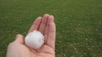
Half-dollar sized hailstones pounding on my windshield will be a sound to never forget. The helpless feeling and thought the windshield might shatter at any moment was enough for me temporarily withdraw from this particular storm chase. On my escape out, I captured these after-the-fact shots of golfball size hail lying around on a baseball field near Rockford, MN. There were reports of baseball, even SOFTBALL size hail in the region earlier in the day. (Yikes!)
Although I fared well, other windshields in the path of these severe storms provided little to no barrier as shown in this image from the Minneapolis Star Tribune.
